
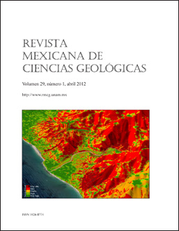
Cover image:
Perspective scene from susceptibility landslides model of Puerto Vallarta, Jalisco, Mexico (Muñiz-Jauregui and Hernández-Madrigal, 2012, pages 103-114 of this issue). Model section view that looks at the Northeast and shows the central part of the city that is cut by the course of the Cuale River to its outlet in the Pacific Ocean. The image distinguishes different degrees of susceptibility (color ramp of red brown to green) on slopes on which the urban structure is located (block’s boundaries) with greater representation of this touristic port.
Published:
2014-01-22

